Site Selection

Fig. 4: map of field sites across North Central Alberta
Study sites were selected using Alberta Vegetation Inventory (AVI) data from various partners of the NSERC Industrial Research Chair in Ecosystem-based Forest Management, including forest industry partners : Alberta Pacific (Alpac), Mercer Ltd., Tolko Industries Ltd. and West Fraser. Additionally, aerial imagery (list imagery from ArcGIS, google earth) as well as provincial datasets (be specific) were used from a variety of sources. Aerial imagery obtained included high-resolution photos provided by some of the partners as well as baselayers from ArcGIS and Google Earth. The AVI data included information on dominant tree composition, structure and age. Information on the occurrence of salvage logging, and remnant island polygon data was also provided by the industry partners.
Between three fires (Flattop Complex Fire, Utikuma Complex Fire, M024 Fire) and two harvesting companies (Alpac, Mercer), a total of 30 island and reference pairs were selected, 15 plots in fire and 15 in harvest. Mortality occurring in reference plots will be thought to act as a sort of "baseline mortality" when compared with island remnant mortality rates, because reference plots will be in a larger forest stand and not entirely surrounded by the disturbance. With an interior and edge plot in each island or reference, a total of 120 plots were established. Alberta boreal forests commonly are of mixedwood species composition, and these forest types are harvested for a variety of uses, primarily for the production of paper and pulp. Therefore, our plots were located in deciduous dominated mixedwood stands containing ≥60% deciduous species (aspen or poplar-P. tremuloides and P. balsamifera), with spruce (P. mariana & P. glauca, pine (P. banksiana/contorta) or fir (A. balsamea) filling out the remainder of the canopy. The fires and harvests occurred between 2009-2011, roughly 10 years prior to data collection. These years for disturbance were chosen because harvesting methods have remained fairly consistent within the past decade, and sampling trees that died more than 10 years previously would become more difficult with more decayed wood and as decay classification increased. Island size was determined by looking at total island size distributions and comparing similar sizes between harvest and fire islands (between 0.45 and 10 ha in size).
Between three fires (Flattop Complex Fire, Utikuma Complex Fire, M024 Fire) and two harvesting companies (Alpac, Mercer), a total of 30 island and reference pairs were selected, 15 plots in fire and 15 in harvest. Mortality occurring in reference plots will be thought to act as a sort of "baseline mortality" when compared with island remnant mortality rates, because reference plots will be in a larger forest stand and not entirely surrounded by the disturbance. With an interior and edge plot in each island or reference, a total of 120 plots were established. Alberta boreal forests commonly are of mixedwood species composition, and these forest types are harvested for a variety of uses, primarily for the production of paper and pulp. Therefore, our plots were located in deciduous dominated mixedwood stands containing ≥60% deciduous species (aspen or poplar-P. tremuloides and P. balsamifera), with spruce (P. mariana & P. glauca, pine (P. banksiana/contorta) or fir (A. balsamea) filling out the remainder of the canopy. The fires and harvests occurred between 2009-2011, roughly 10 years prior to data collection. These years for disturbance were chosen because harvesting methods have remained fairly consistent within the past decade, and sampling trees that died more than 10 years previously would become more difficult with more decayed wood and as decay classification increased. Island size was determined by looking at total island size distributions and comparing similar sizes between harvest and fire islands (between 0.45 and 10 ha in size).
Plot Setup
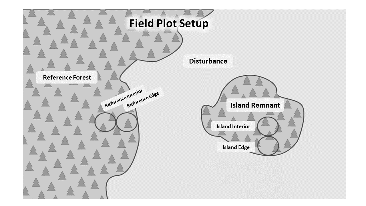 Fig. 5: diagram of plot setup, with edge and interior plots tangential to each other and in both reference and island remnant stands. Reference plot mortality will act as the "baseline" or control mortality to compare to island remnant mortality
For each location (island or reference), edge and interior plots were established located tangentially, with the edge plots bordering the disturbance. Reference forest had a edge plot bordering the same disturbance as each corresponding island edge plot. Each plot is circular with a radius of 11.28m, for a total of 400m2 total area (Alberta Growth & Yield Initiative 2015). Plots were established in Summer 2021. All stems ≥9.1cm were tagged, measured, identified, and standing dead trees given a visual decay class (ABMI Terrestrial Field Protocols, Angers 2011 Dissertation, Lutz et al. 2020: Smithsonian ForestGEO deadwood protocols, Janík et al. 2018)
In-Field Data Collection
Standing dead trees will be visually dated according to a 5 level decay class system. Decay class 1 and 2 are thought of as having died in response to the target disturbances of interest (the fire or harvest, occurring from 2009-2011) supported by the ABMI Terrestrial Field Protocols. ABMI Terrestrial Field Protocols define stage 1 snags as recently killed, with all twigs/branches present, wood hard, and bark (normally) intact. Time since death of specific species (trembling aspen and white/black spruce) was estimated as P. tremuloides snags with 90% bark still intact were dead less than 10 years, time since death of P. mariana was strongly correlated to twig presence on snags and bark cover was an important characteristic common to all species in predicting time since death (Angers 2011 Dissertation.) Further support for visual dating based on decay class from Lutz et al. 2020 and Smithsonian ForestGEO deadwood protocols (Janík et al. 2018), where Class 1 snags are defined as freshly dead (0–5 years for many species) with the species still recognizable; branches of 3rd order are present; the full height of stem is present unless there was damage prior to the mortality event or caused during the mortality event, and with bark fully intact.
Data Analysis
Because the data I have available for this project is univariate, I will be building linear fixed-effects and mixed-effects models and performing ANOVAs on those models to determine if mortality differs between explanatory variables. Linear models incorporate controlled variables (disturbance type, site type, plot location) as well as uncontrollable errors resulting from random effects to predict response variables.
Predictor variables: disturbance type (harvest vs. fire), site type (edge vs. interior), plot location (reference vs. island), tree species, island size
Response variable: tree death--mortality rates calculated from number of dead Decay Class 1 or 2 stems compared to total stem count of each plot, and species mortality rates (species-level mortality rates)

Fig. 7: experimental design schematic, with plots divided by disturbance type (fire and harvest) first, then in either a reference or island location--there are 15 island/reference pairs per disturbance. Then each reference and island has an edge and interior plot, for a total of 120 field plots for sampling.
References
Alberta Agriculture and Forestry and the Forest Growth Organization of Western Canada. Alberta Provincial Growth & Yield Initiative (PGYI) 2015. “Minimum Standards and Suggested Protocol and Priorities for Establishing and Measuring Permanent Sample Plots in Alberta.” July 22, 2015.
Alberta Biodiversity Monitoring Institute. 2014. Terrestrial field data collection protocols (abridged version) 2018-05-07. Alberta Biodiversity Monitoring Institute, Alberta, Canada. Report available at: abmi.ca [March 5, 2021].
Angers, Virginie A. “Snag dynamics in boreal mixedwood and coniferous forests.” PhD dissertation. University of Quebec Montreal. (2011)
Stokes, Marvin A. An introduction to tree-ring dating. University of Arizona Press, 1996.
Janik, David, Kral, Kamil, Adam, Dusan, Vrska, Tomas, Lutz, James. “Smithsonian ForestGEO Dead Wood Census Protocol.” In: Utah State University Digital Commons Paper 76. Logan, Utah.
Lutz, James A., et al. "Large-diameter trees dominate snag and surface biomass following reintroduced fire." Ecological Processes 9.1 (2020): 1-13.
